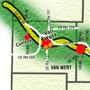
Bridge near Van Wert, Ohio
Directions to Plaque Bridge and Indiana state line.
From the center of Van Wert, drive westerly with Main Street. Use mileage as shown.
0.15—Brumback Library at Right was the first county library in the United States (1901); at Left, opposite the library is a restored concrete post
0.7—Spray's Radiator Service is at northeast corner; has nice display of petroliana signs; began as a Shell station in 1927
0.8—B&K Root Beer stand at Right; original neon sign
1.0—Stipe's Westside Motel at Right
1.2—Old Carl G. Wright complex at Left; post cards list "modern cabins, restaurant, garage, service station, and barber shop"
1.7—Former Restwell Motel at Left
1.9—Ridgeway Drive-In Theater at Right was formerly Lincoln Drive-In
2.4—After stop sign at U.S. Route 224, continue westerly with Lincoln Highway
3.7—Original roadway angled sharply here, passing at the immediate north edge of the cemetery; remains of a small culvert are sometimes visible in the grassy area at the southeast corner of the Richey Road intersection
4.6—Replica Burma-Shave signs at Right
9.4—Where Dixon-Cavett Road angles Left, continue northwesterly with the Lincoln Highway for 0.1 mile to observe the bridge over Upper Prairie Creek, which has Lincoln Highway signs in the ends of the parapet walls.
Drive westerly on Dixon-Cavett Road toward U.S. 30 to end at state line.
Thanks to This email address is being protected from spambots. You need JavaScript enabled to view it. and his "History and Road Guide of the Lincoln Highway" in Ohio for these instructions.
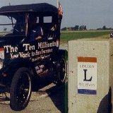
Lincoln Highway ceramic plaques on the bridge nine miles west of the city of Van Wert.